The idea of participating in the Tushars 93K was placed in my head by friend and stellar runner Megan Hansen. At that point, I thought it sounded crazy. I love a day out on the trails bagging as many peaks as I can, but the idea of 17,000 ft. (!) of vertical gain seemed a little out of reach. Throw in the fact that the race climbs to over 12,000 ft. and has an average elevation of over 10,000 ft., my only thought was "how am I supposed to breathe up there?"
I accepted her invitation, not really having any idea what I was getting myself into, and continued my training. My home is on the East bench of Ogden, UT, and I have hundreds of miles of sweet singletrack right outside my front door. I was slightly concerned about the elevation difference (the peaks around my neck of the woods don't break 10,000 ft.), but I was banking on adrenaline and the downhills to supplement my lack of oxygen on the climbs. After what seemed like the blink of an eye, it was almost time for the race. My longest day up to that point had consisted of 34 miles and 8,000 ft. of climbing. Just the thought of doubling that vert and adding 25 more miles in the process made me a little sick to my stomach...
 |
| The Tushar mountain range is a hidden gem located just East of Beaver, UT, featuring stunning 12,000 foot peaks. |
As we pulled in that Friday afternoon, I was taken back by the beauty and size of these mountains that I never knew existed. It was pretty amazing terrain and it did a good job of intimidating me just by looking at it from the car. We arrived to the start/finish point of the race at the Skyline Lodge at Eagle Point Ski Resort. Runner check-in was a breeze, dinner was served, and it was time to hop in the back of the 4Runner for what would be a sleepless night. In all honesty, as I lay there in the back of my car with no hope of getting any sleep, I wasn't optimistic about the race that was about to start. I just wanted it to be over.
Race time.
I tried my best to stick to my normal pre race routine with a peanut butter sandwich and a banana before the 5:00am start. As we stepped up to the line, the race organizers once again reminded us of the difficulty of this course. "Do not approach this course lightly" and "You should seriously consider dropping at these aid stations" were the encouraging statements I needed to hear to get me going (note the sarcastic tone of the text). 5, 4, 3, 2, 1. We were off in the black of morning, following the string of headlamps heading up the mountain.
The first few miles of the race were slow. We were bunched up on single track, few places to pass anyone, and I had no idea what my pace was supposed to be for that leg of the race. I was trying to determine early how my body was holding up. Everything felt good, until I stepped into a wet marsh. Dang it. Then the rain/hail started. Really? We hadn't even made it to the first aid station yet. The little storm was broken up by an amazing sunrise that I was thrilled to see. We reached the first aid station at about 7:00am and my optimism was slowly building. With the sun coming out and the first aid station behind me, it was time to climb the first real mountain of the day, Mt. Delano, which would be the high point of the race at over 12,100'.
The climb up Delano was beautiful. I had no idea we had this kind of landscape close by, right outside little old Beaver, UT. We passed old mining cabins that had me puzzled as to how they lived in such rugged terrain so long ago. I wasn't exactly sure what we were climbing to, because the peak was engulfed in the clouds. "One step at a time," a phrase I would repeat often during the day.
 |
| Looking at the climb to Mt. Delano. I had no idea how far up we would go because the peak was blocked by the clouds. |
 |
| A steep section of the climb on the way to the ridgeline that we would eventually follow up to the summit. |
 |
| I was glad to still have enough sense this early in the race to turn around and appreciate the views before we climbed into the clouds. |
The summit came out of nowhere in the thick clouds, and I was stoked to see that little sign (also glad that I was still breathing ok after climbing to over 12,100'. At the summit, the wind was howling and I didn't have much feeling left in my hands. All I could think about was getting to some lower elevation to warm up.
 |
| Top of Delano, 12,169 ft., at mile 12.5 of the race. |
As we ran down the other side of Delano, the 1/2 marathoners were making their way up to the summit. It was fun being on that mountain with so many other people. Everyone's stoke was still very high at this point and everyone cheered each other up, and down, that hill.
After descending Delano, we climbed a dirt road up to the second aid station at mile 16. Here I was happy to see Alexa and to notice that I was more ahead of the cutoff time than I had anticipated. I didn't hesitate in taking some sips of a Canada Dry, grabbing some Oreos, and refilling my water pack. After waiting for a few minutes to see the crew I had started with, I knew I had to keep moving. The next 6 miles were going to be a fun, quick descent down to Blue Lake before climbing back up to a mountain pass to mile 24's aid station.
 |
| Ali grabbed this super flattering shot as I grabbed a quick drink and a snack. |
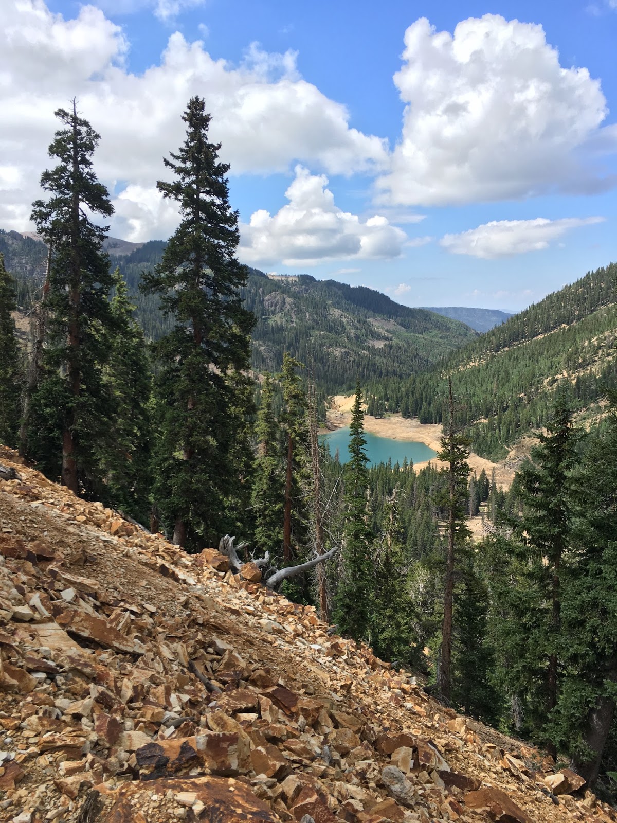
Miles 16 to 22 were probably my favorite of the entire day. It was downhill on amazing single track through forests and above cliffs, eventually making its way to a very cool Blue Lake. The title picture at the top of this post is one I snapped during this descent, I enjoyed views like that for the duration of the race. This was also my fastest leg of the race. I knew that I would have to take advantage of the downhill portions of the course if I had any hope to finish before the cutoff. Gravity was definitely going to be hurting on the (seemingly) endless climbs, so I made sure to let it pull me down those hills as much as my legs would allow. After reaching the valley floor and the lake, we started another 2,000 ft. climb up to Bullion Aid Station, located at mile 23.5. This climb felt long, but I credit my good time going up to Katy Perry and gummy bears, both of which played an integral role in carrying me up to the pass.
 |
| Enjoying the views of Blue Lake on the climb up to Bullion Aid Station |
At Bullion Aid Station I opted for the Coca-Cola Classic and the grilled cheese. I was again stoked to see that I was moving over an hour ahead of the cutoff time for this stop. I wasn't sure how long my good spirits would last, so I decided to move pretty quickly through this station. I knew that Copper Belt Peak was waiting for us to summit and that it wouldn't be easy.
 |
| Ali again was dialed in her Aid Station photography, capturing another stunner of me at Bullion Aid Station.. (Mile 23.5) |
After leaving Bullion for the first time, we would descend to the Copper Belt Peak aid station (3 miles later) before heading up to summit the mountain. It was a killer climb, but I would learn what a killer climb
really looked like later in the race... After reaching the peak (mile 30) I grabbed a few pictures, did a quick evaluation as to how my body was holding up, threw down some gummy bears, and geared back up for what I hoped would be a quick descent of the mountain. On my first step off the peak, I felt a sudden pain shoot from the bottom of my knee all the way up to my hip. "Oh sh!#" were the first words out of my mouth (sorry mom). It was the IT band. Why is it always the IT band? I took a couple more steps to see if it was just a weird movement on my end, but the pain continued. My downhill running turned into a downhill stumble/shuffle mixture and my optimism was tanking. I thought for a few minutes that Tushars had won and I would be done. My strategy of moving quickly downhill was now a bust. I was relieved when I started the climb back to Bullion Aid Station for the second time and felt little to no knee pain while climbing, only on descents. I climbed quickly back to the pass and looked forward to a arriving at the aid station to reassess my situation. Do I keep going? Do I quit?
 |
| The views from Copper Belt Peak - Seriously, the views in this race are awesome. |
 |
| Back at Bullion Aid Station (mile 36) throwin' down some ibuprofen and wishing my knee brace would be of any help. |
When I got back to the Bullion Aid Station at mile 36, I saw that I was still over an hour ahead of the cutoff. I thought to myself - I'll take 5 minutes and see how I'm feeling, because if I leave this aid station, I have to finish. The race organizers warned us prior to the race that if we were going to drop, this was the place to drop. Extracting someone beyond this point would be difficult and you'd probably be better off walking to the end regardless. Encouraging, right? I was thinking out loud to Alexa about what I should do and I think my rambling went something like this. "Well, I know the next 6 miles are all downhill, and that is going to hurt. Then I'll have to do the hardest climb of the race - 4,000 ft. from mile 43-47 - and that is going to suck, too. I can't remember what the last 10 miles after that will be like, but I can't imagine they'll be much fun at that point. But I've given myself a good amount of time, so I think I'll do it. I'm going to finish."
I was eager to see how my knee would hold up for the next 6 miles as we would descend nearly 4,000 feet to the low point of the race (just over 7,500'). I told Ali I would see her at the finish, whenever that might be, and went on my way.
 |
| Leaving Bullion Aid Station for the last time and beginning my 6-7 mile descent toward Miner's Park Aid Station. |
The descent was brutal, but I managed to keep my pace up while trying anything to minimize the pain. I would occasionally stop to snap a pic or focus on the scenery rather than running. We ran down open meadows, through lush forests, and past the incredible Bullion Falls en route to Miner's Park Aid Station at mile 43.
 |
| Bullion Falls, somewhere around mile 41. |
 |
| Descending through meadows to Miner's Park Aid Station |
I spent little time at Miner's Park aid station because I knew what was ahead and I just wanted to get it over with. The next 4 miles would be long and time consuming. We would climb 4,000 feet to mile 48, and it was by far the most difficult portion of the race. I found myself stopping often to eat anything I could grab out of my pack. I needed something, anything, to give me more energy.
The night before the race, while we were eating dinner, I was asked, "What is the most physical suffering you've experienced?" I wasn't sure at the time, but I now have a very clear answer. We followed switchbacks up for a few miles and a few thousand feet. I thought we were near the top when we got above the treeline. When the trees cleared and I saw the route on which we would continue to the summit, I was crushed. We would abandon the trail and climb straight up the face of this mountain to the top, another 1,500' above us. I was exhausted. Just looking up made me want to cry. I figured that crying wouldn't do me much good at this point and my only option was to go forward. It was very slow, but I continued to put one foot in front of the other, basically pulling myself up the mountain with my trekking poles, until finally I reached the top right as the sun was setting. The views from the peak were, again, spectacular, but it was much more difficult to appreciate what I was seeing at this point.
You could see the final aid station below the peak, though the route down was a deceptively long route (another 2 miles) until I finally arrived. This last aid station was also our first aid station earlier in the day. From here, we would follow the same 8 mile trail back to the start/finish line and call it a day.
Shortly after leaving the final aid station, we were engulfed in the dark woods. Apparently at some point during the day, a group of hunters out spotting for elk had removed the course marking ribbons on this stretch of the course, believing that the ribbons were "scaring the game away". I was soon lost in the woods, desperately looking for anything that resembled a trail. I was very much ready to be done with this race, and the idea of spending the night lost in the woods was unacceptable. After 30ish minutes of simple wandering, I saw a headlamp coming down the mountain side. Turned out to be the race organizer, Matt, and he was replacing the ribbons for the rest of the runners. I was super relieved to know I was back on course and heading the right direction to the finish.
After making my way over a couple more passes, I knew I had to be getting close. After a few more miles, I saw another headlamp running up the trail in my direction. It turned out to be Jeff Davis, one of the people who I had started the race with but called it a day after Copper Belt Peak, and he had come to see me through to the finish. Another few minutes of shuffling down the trail and there it was, I small arch, covered in Christmas lights, coming out of nowhere in the dark night.
 |
| The finish. |
This race was the real deal. The course was absolutely stunning, but killer. 17,000 ft of climbing in 60 miles was no joke! This race has a reputation of being difficult, and I can clearly see why. This race, however, is a great chance to explore a part of the state that not many people visit. The Tushar mountains are pretty special, and I hope they continue to put on this race for years to come. I may even have to come play again!